


This version does not work with Gaia GPS.

Click on the above image to download a sample of the PDF.
This is a sample of the 2023 WhiteBlaze Pages PDF.
It does not include the entire PDF, but it gives you enough to see what is included in the book.
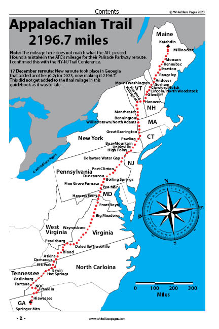
I have included the entire Approach Trail and the Appalachian Trail from Sprinter Mountain to Franklin, NC.
What you get
** You will be notified of PDF updates and will be able to download the newest version for free. **
These are live updates. You get notified when there is an update by email, provided that you asked to be notified.
Updates are not just notifications of changes; you are able to download a completely new updated PDF (the whole version). All updates for the WhiteBlaze Pages 2023 PDF version are free if you previously purchased a WhiteBlaze Pages 2023 PDF version.
This PDF is designed for printing out on a printer.
Here are just a few more features included in the PDF
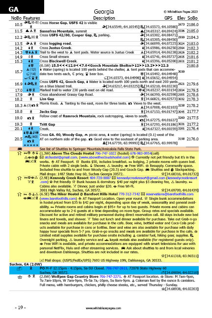
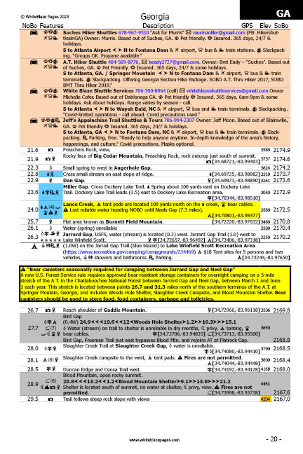
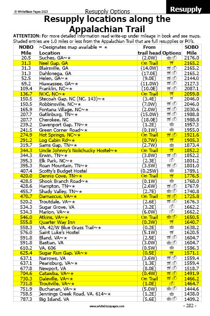
- WhiteBlaze pages is designed for easy use by all variety of hikers: day hikers, section hikers, and long-distance thru-hikers, (NOBO, SOBO, and flip-floppers). Its goal is to assist you to quickly determine your location and surrounding terrain features, and to find nearby re-supply options and other needed services.
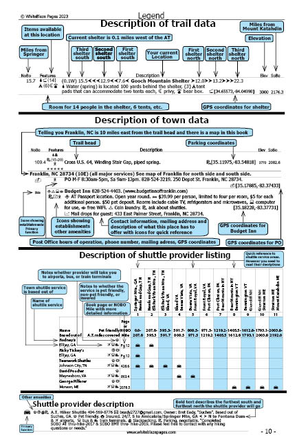
- Mileages for NOBO hikers are on the left outer edge of the pages. For SOBO hikers the mileages are on the right outer edge of pages. This was done so that you could easily thumb through the pages and find the mileage point you’re looking for very quickly for both NOBO and SOBO hikers. No other guidebook does this.
- Easy-to-read descriptions, coordinates, and elevations, listing over 4,904 data entry points of trail-worthy information, (more than any other Appalachian Trail guidebook), allowing for easy use, no matter what direction you are hiking, NOBO, SOBO, or flip-flop, a unique feature of this guidebook.
- Over 5,000 GPS coordinates listed in this guidebook locating shelters, trail heads, road crossings, landmarks, establishments, attractions, and also listing Appalachian Trail parking locations, with parking capacities.
- Over 700 listings of possibilities for parking locations.
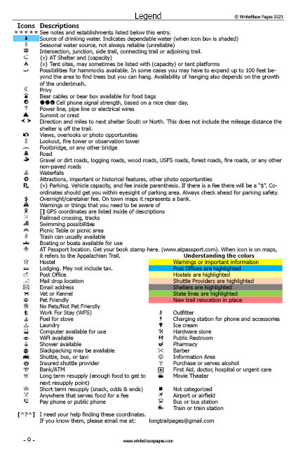
- Quick-reference icons (74) and colors, associated with detailed descriptions that allow you to rapidly determine the availability of needed services, at any particular location.
- Background colors are highlighted for quick reference to hostels, shuttle providers, shelters, State lines, Post offices, and dependable water sources. Color blind friendly.
- 142 maps and road crossings maps are in the guidebook to better assist the hiker.
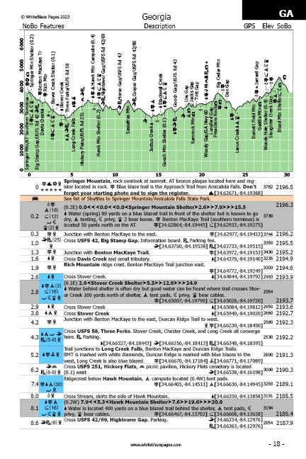
- Up-to-date elevation profile maps, in easy to read 30-mile sections, displaying locations, with quick-reference icons positioned adjacent to the locations, items listed on profiles are in bold type in the accompanying description.
- All items listed on the profiles are bolded on the data pages for quick reference.
- Each shelter location shows the mileage to the next three shelters north, and south, for quick reference.
- City and town informational entries, in sequential order, referenced to trail mileage, in detail. No need to flip back-and-forth, 2 or 3 pages through the guidebook to locate needed information, unlike in other guidebooks.
- All maps are to scale, north oriented, showing the locations of thousands of establishments providing needed services, unlike other guidebooks that do not have their maps to scale.
- Many trail features: side trails, waterfalls, bridges, scenic views, attractions, road crossings, bridges, power lines, warnings, and much, much more!
- Complete Post Office addresses, phone numbers, and GPS coordinates in the town’s listings.
- Post Offices are also listed in their physical locations where you would use them along the Appalachian Trail.
- Listing of Appalachian Trail resupply locations. Good for pre-hike planning.
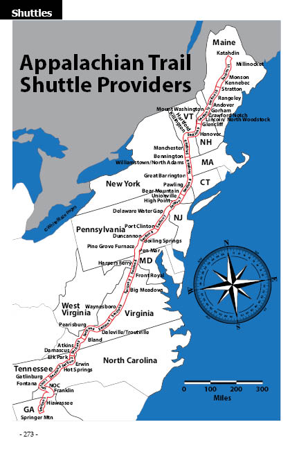
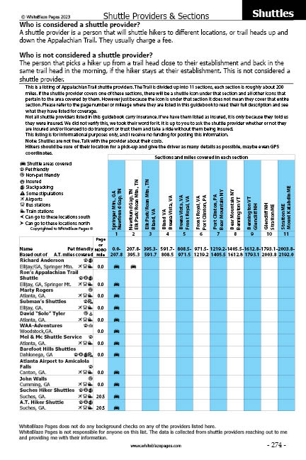
- Includes an extensive listing of all shuttle providers along the entire length of the Appalachian Trail, with descriptions and shuttle service area map. The most up-to-date listing in publication!
- Approach Trail, including profile, elevations, coordinates, and Amicalola Falls State Park information.
- Contains a separate Hostel listing of all Hostels. Hostels are also listed in their physical locations where you would use them along the Appalachian Trail.
- Includes a table of contents. Index for the book, and index of maps included in the book.
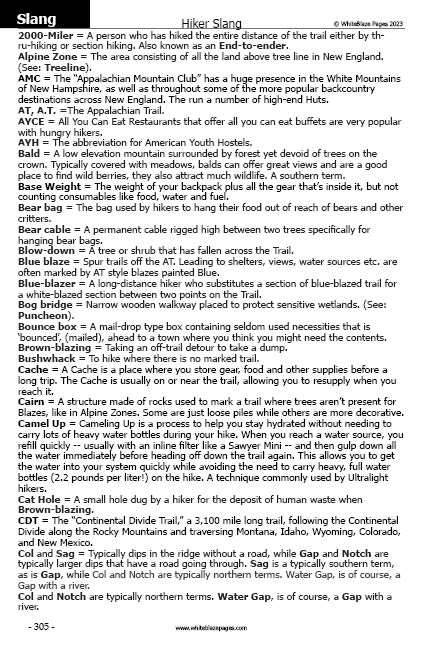
- Hiker Slang, commonly used hiker terms.